
ARCFISH
Digital Twin of the Ocean for Arctic Fisheries will develop new data products and services for improved decision-making in fisheries management to support sustainability and resilience of Arctic fisheries.
OLAMUR
Development of tools for aquafarming co-usage at offshore wind farms
EDITO Model Lab
EDITO-Model Lab is a Horizon Europe project working to develop the next generation of ocean numerical models to be integrated into the EU public infrastructure of the European Digital Twin of the Ocean (EDITO-Infra) and providing access to focus applications and simulations of what-if scenarios for the sustainable management of marine environments
MarinePlan
Transdisciplinary science for effective ecosystem-based maritime spatial planning and conservation in European Seas
OceanICU
Understanding of the biological carbon pump
BlueCea
Key processes governing pelagic productivity in sub-arctic North Atlantic fjord ecosystems
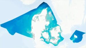
Denmark's Depth Model (DDM)
Denmark's Depth Model (DDM) is a digital bathymetric model with mean depths, covering Denmark's exclusive economic zone (EEZ). The model has a resolution of 50 metres and is based on a collection of hydrographic surveys and other sources.
NOCOS DT
The NOCOS DT project applies digital twin technology to sea ice research in the Nordic, Arctic and Baltic regions.
CodeBlue
Harmonised ocean data sets for blue sustainable eutrophication management of the North-East Atlantic Ocean and Baltic Sea.
MOIRAI
Multiscale Ocean models and Information for climate Risk Assessment and Impact mitigation. Development of state-of-the-art ocean modeling to be able to make more robust climate projections for both the ocean and coastal areas.
Global Seas
DHI Global Seas provides global forecasts of winds, waves, ocean currents and water levels where satellite data are used to improve and validate the wave and current models. The service is targeted at offshore wind and shipping but supports all users working at sea
DTO4OWE
The project aims to develop a sub-regional Digital Twin Ocean for offshore wind energy in the Baltic-North Sea. DMI focuses on building up a DTO for Baltic-North Sea transition waters and also leads a workpackage developing data-driven tools for forecast optimization, downscaling and data fusion
Mission Atlantic
The project aims to develop a sub-regional Digital Twin Ocean for offshore wind energy in the Baltic-North Sea. DMI focuses on building up a DTO for Baltic-North Sea transition waters and also leads a workpackage developing data-driven tools for forecast optimization, downscaling and data fusion
DTO Bioflow
In the EU Digital Twin Ocean create a digital replica of marine biological processes
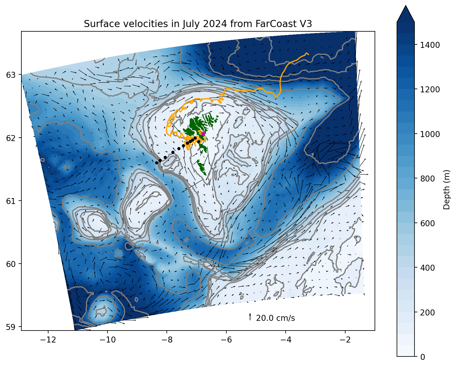
FjordProcesses
Investigating fjord shelf processes in Faroe Islands with FarCoast model, making a high resolution coastal hindcast library (130m x 130m) available through thredds. Making hydrodynamical data readily available for biogeochemical models.
ADepoPlan
ADepoPlan - Accessible deposition modelling tools for improved environmental planning. The overall objective of this project is to improve the environmental planning toolbox for the Faroese industry and government by making validated deposition models more accessible to stakeholders with limited modelling and programming experience.
Skærkortlægning in Greenland
The purpose of the pilot project is to map the coastal areas in Greenland using satellite technology in order to improve coastal navigation and navigational safety. The project will focus on, among other things, the determination of tidal zones, refinement of coastlines, and identification of high-risk areas. This will benefit the search and rescue services in Greenland (SAR), voyage planning, and general navigational safety.
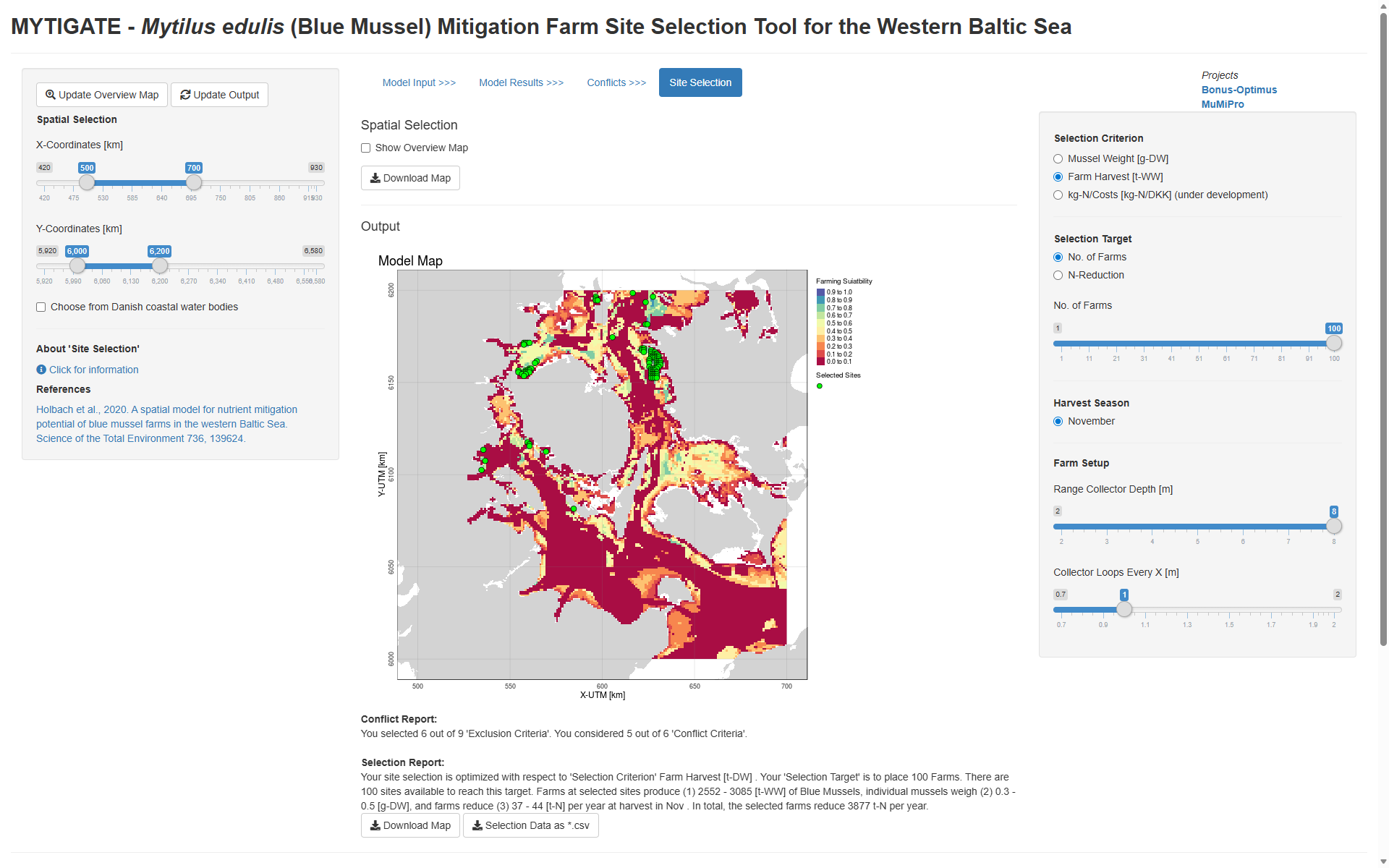
Mytigate
Mytigate - site selection tool for mussel farming. Mytilus edulis (Blue Mussel) Mitigation Farm Site Selection Tool for the Western Baltic Sea.
OLAMUR
Micro-siting tool for site selection of low trophic aquaculture in offshore wind farms.
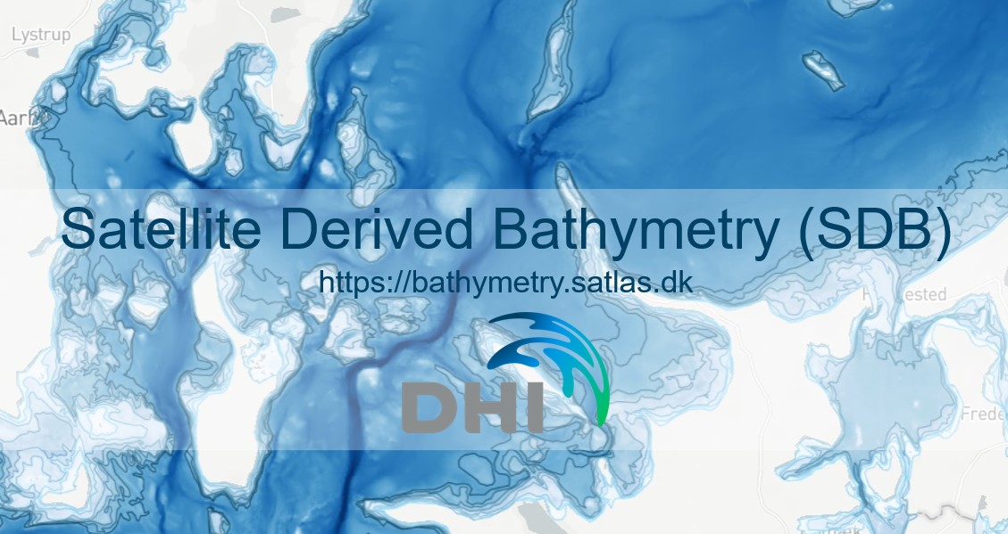
Coastal Bathymetry
Satellite-based mapping of bathymetry to create a fully up-to-date and detailed depth model of the shallow part of the Danish coastal zone.
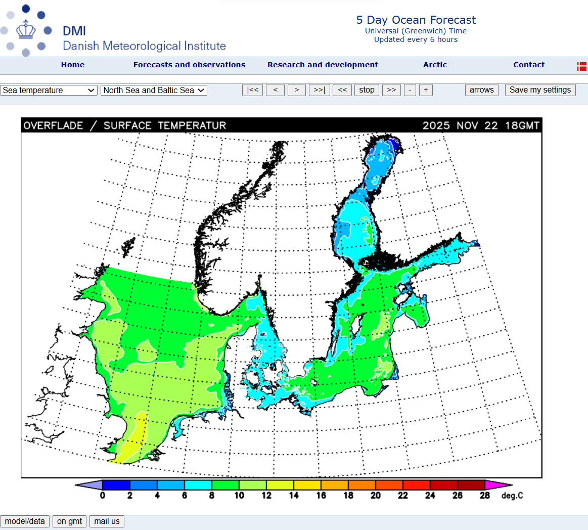
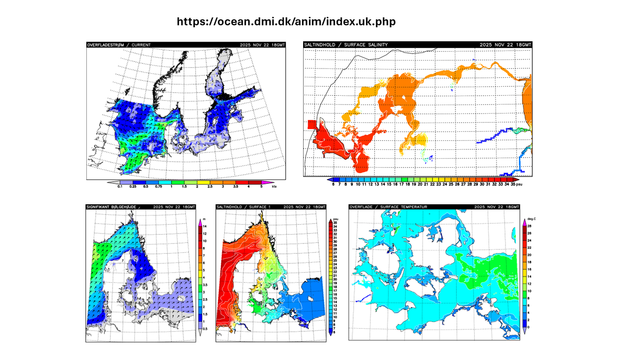
Prognosedata
Havprognosedata 5 dage for Nordatlanten, Arktis, Disko Bay.
Baltic Sea Physics Reanalysis
Baltic-North Sea high resolution physical-biogeochemical ocean reanalysis. This reanalysis is a Copernicus product generated by DMI (1993-2023, 1 n.m. resolution), to be extended to 1980 by 2025.
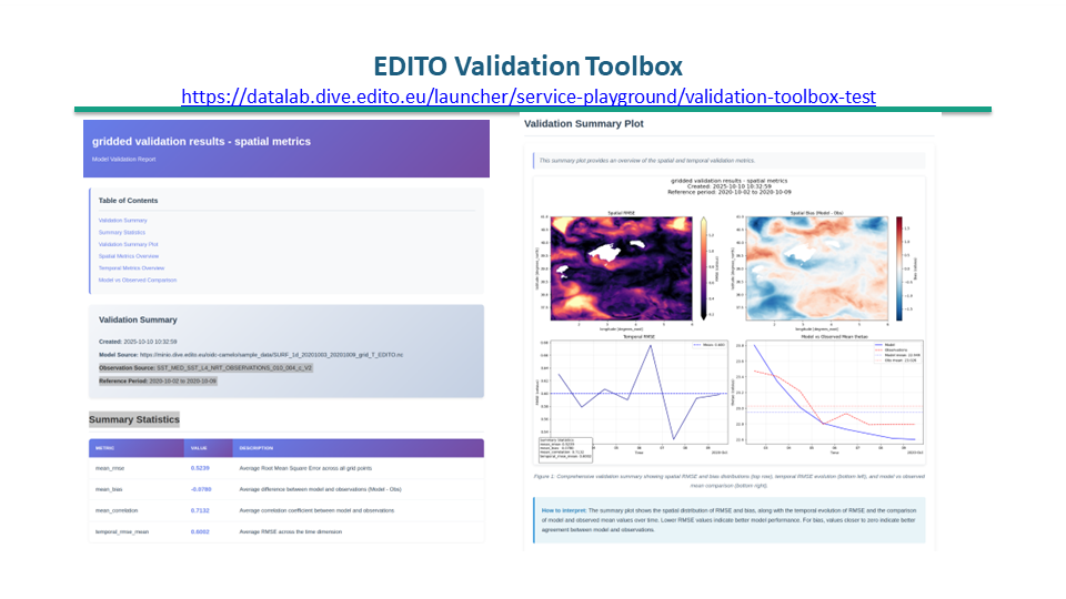
EDITO
Commn Validation toolbox. Impacts of offshroe infrastructure and vegetation will be parameterized in the DMI ocean-wave model HBM-WAM.

IBMlib
Generic framework for coupled individual-based simulation
Forecast Data
Download of raw forecast data from our own forecasts for use in other systems, e.g. GRIB for navigation software.
FMHAT
FMHAT - Fjord modeling with the FarCoast model and HPC in the Faroe Islands. A 20 year hindcast data set from FarCoast model from 2000 to 2020 with 2km resolution for the Faroe shelf and beyond, will be available though thredds later this year.

FlexSem.
FlexSem - open access dynamic model tool. The modeling framework FlexSem is a fast, flexible and user friendly OA tool specifically targeted towards scientific and management challenges of the complex biogeochemical processes in coastal zone ecosystems.
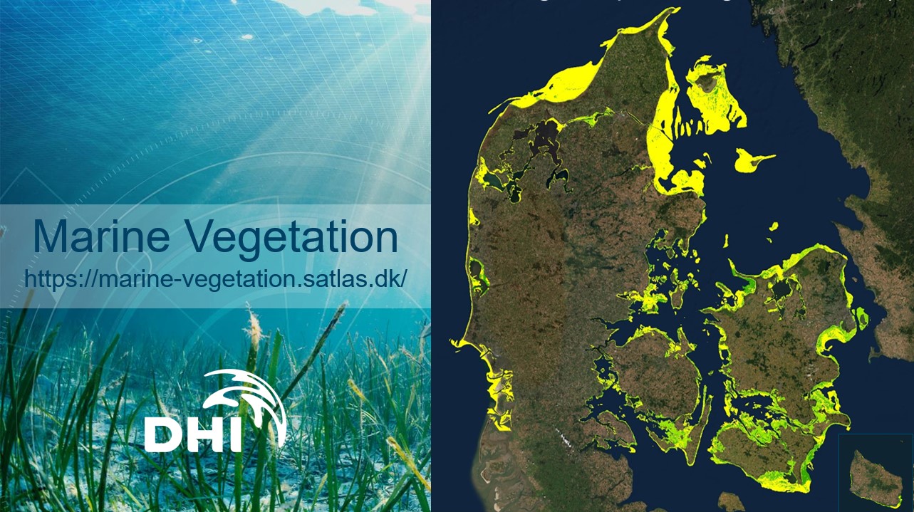
Marine Vegetation
Mapping of Submerged Aquatic Vegetation from satellites.

GASPOC
Global Atlas of Siting Parameters Ocean and Coasts.
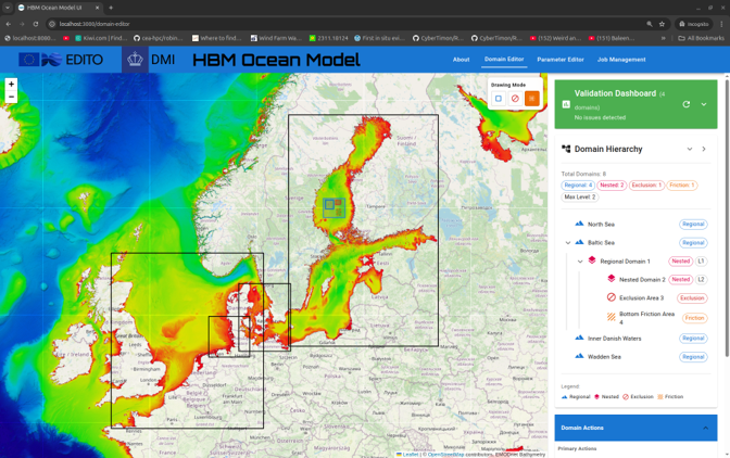
HBM
HBM - on-demand model tool. On-demand HBM enables users to automatically set up and simulate a subdomain in the Baltic-North Sea with a resolution up to 50m.
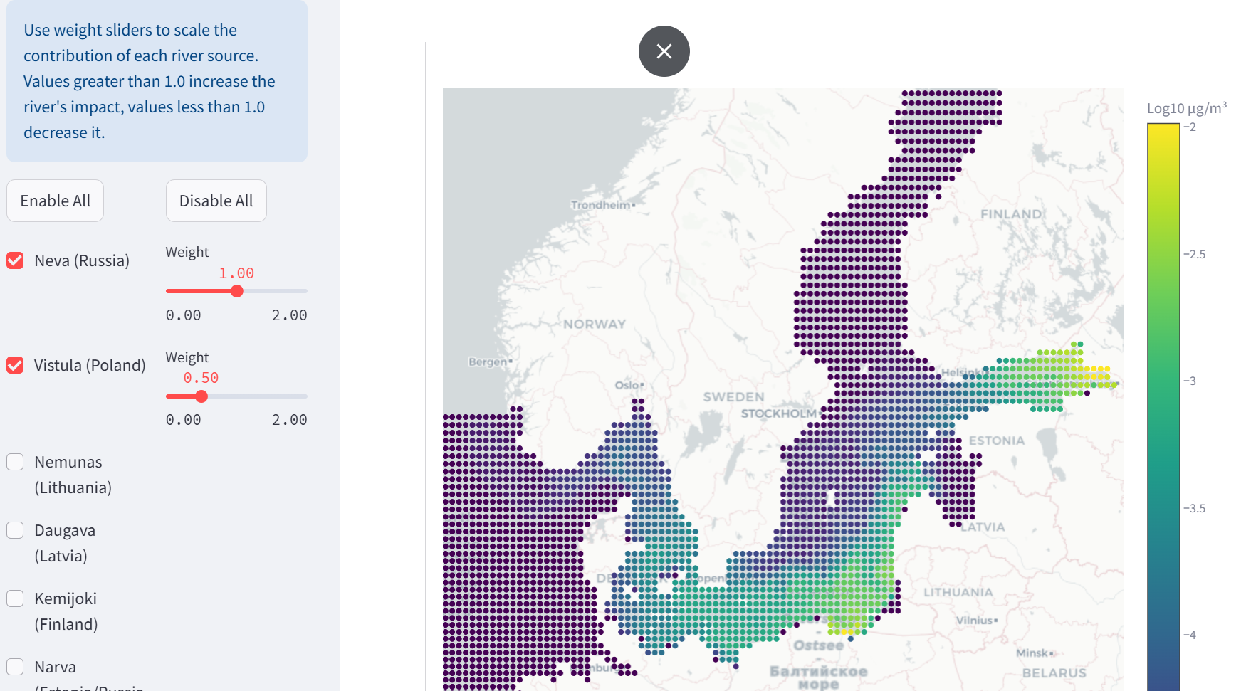
HBM-MP
HBM - on-demHBM-MP for microplastic modellingand model tool. On-demand modelling for sources, pathways and fate of land-based microplastic in the Baltic Sea region.
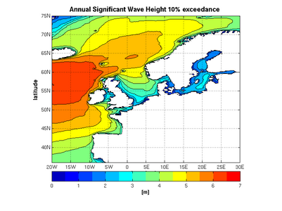
Wave hindcast
15-20 years wave simulation data in 1-25 km resolution for N. Atlantic-Baltic-North Sea-IDW
GridWetData
Python classes for accessing and analyzing gridded ocean data
Geolocated Forecasts
A range of services providing access to meteorological and oceanographic forecasts for the exact locations and times of interest, displayed as graphs.

Denmark's Depth Model (DDM)
Denmark's Depth Model (DDM) is a digital bathymetric model with mean depths, covering Denmark's exclusive economic zone (EEZ). The model has a resolution of 50 metres and is based on a collection of hydrographic surveys and other sources.